Utility Infrastructure Mapping Benefits
Most SUE professionals understand that this is not a linear process, but the quality level basic descriptions often imply otherwise.
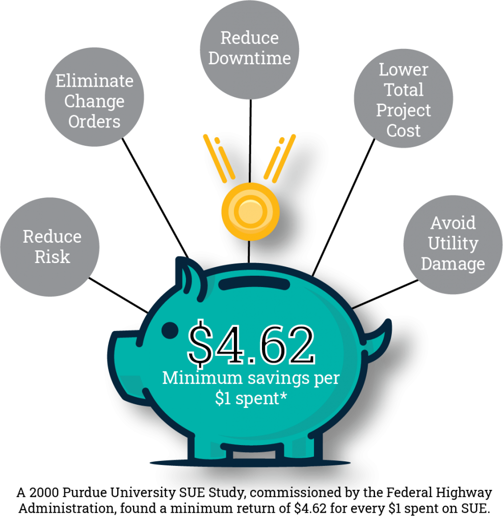
Why use SUE/UIM?
Because it's a smart decision to mitigate risk early in the design process.
Since the 1980s, infrastructure mapping has reduced total project costs and compressed schedules. Reliable mapping of existing utility infrastructure is as important as an accurate topographic survey of existing conditions. The simple fact is that contractors prepare bids based on construction documents. When construction documents don’t reflect existing conditions, contractors have a legal basis to recover the resulting cost overruns.
Constructible designs cost less to build, and this common-sense fact applies to all types of construction, from utilities and pipelines to schools, hospitals, and multiuse real estate development. In 2000, The Federal Highway Administration commissioned a study by Purdue University to analyze the effectiveness of utility mapping in reducing costs and delays on highway projects. It found that each dollar spent on utility mapping produced a minimum of $4.62 in savings. In addition, accurate depiction of utilities on construction plans enhances the safety of construction workers and the public by reducing utility damages and service disruptions.
Involves document research and gathering of utility records from all available sources including utility company records, as-builts, field notes, and verbal recollection. This is considered to be the least accurate level.
Information is obtained by topographic feature surveys and plotting of above ground appurtenances relative to quality level D information.
Utility information is obtained through the application of appropriate surface geophysical methods, typically electromagnetic detection, to determine the existence and approximate horizontal position of subsurface utilities. Quality level B data should be reproducible by surface geophysics at any point of their depiction. The information is surveyed to applicable tolerances defined by the project and reduced onto plan documents.
A precise horizontal and vertical location of the utility is obtained by physically exposing the utility. Using a vacuum excavation unit to remove earth and debris enables operators to confirm the utility, its horizontal and vertical position, condition assessment, and collect descriptive size and material type. Accuracy is typically set to 15mm vertical and to applicable horizontal survey and mapping accuracy as defined or expected by the project owner.
Using our extensive industry knowledge and years of experience allows our InfraMap staff to effectively understand the needs of each project and make appropriate recommendations for investigation. We are thoroughly familiar with the complexities and constructibility issues which must be accurately and efficiently addressed by a utility location consultant. Given the enormous liability, as well as the expensive and dangerous consequences associated with errors, we understand the trust our clients instill in us when hiring our firm as their project partner. We do not take that trust lightly, and we make it our prime objective to always “get it done right, the first time.”