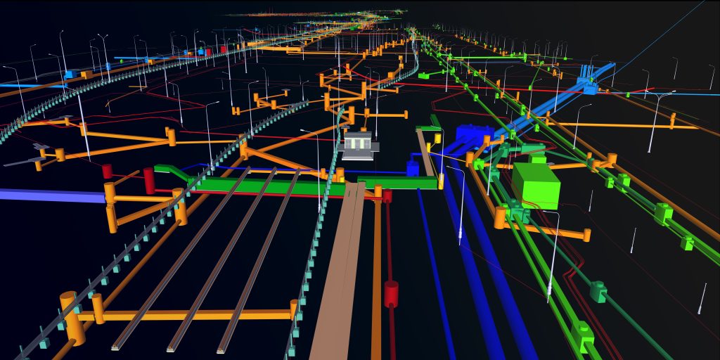
3D Utility Mapping
Advanced highway design needs enhanced utility data
The Future of Utility Mapping is 3D, but how do we get there?
Roadway and highway design has seen significant technological advancement with increased computing capabilities and the adoption of 3D design and modeling platforms.
Why Use 3D Utility Mapping
Reliable 3D utility data allows engineers to visualize existing infrastructure about proposed designs in a new way. Enhanced visualization enables the designer to accommodate existing infrastructure, reducing the overall cost and the risk of unforeseen conflicts, change orders, and delays. To provide reliable, accurate 3D designating data, advances in technology and data collection workflows are needed.
The 3D challenge
Collecting and depicting accurate 3D data for subsurface utilities is an emerging field and the focus of our R&D efforts. Currently, no single technology can accurately and consistently image buried utilities in three dimensions under all site conditions. Using 3D utility data also requires the development of data models and data dictionaries to maintain consistent definitions of utility attributes. InfraMap has already developed base models and data dictionaries for all standard utility systems.
Our approach
InfraMap recognizes the growing unmet need for accurate 3D utility data.
The lack of practical solutions for utility imaging unaffected by soil conditions and terrain led to our decision to focus our R&D efforts on this challenging problem. Years of R&D effort have resulted in a revolutionary imaging system currently in field trials. The new system uses data collection software specific to the 3D mapping task. It visualizes utilities in real-time in the field, adds utility attributes using pre-loaded data dictionaries, attaches survey-grade coordinates, and exports data in several formats. Best of all, it works in all soils over the roughest terrain. In support of this core technology, we are developing applications for managing point cloud data from internal manhole and vault scans to integrate our 3D utility linework with these structures and standard pre-modeled utility related structures.
What about radar tomography?
Radar Tomography (RT) is usually performed with an array of towed GPR antennas. It has been the subject of much development work for over twenty years. Unfortunately, RT (AKA Multi-Channel GPR) has limitations that can’t be fixed. The main limitations are soil conditions and terrain.
It’s all about the soil.
Since RT is performed using multiple GPR units, connected RT suffers from dependence on soil properties as GPR. Many soils are opaque to GPR signals, especially mineralized and water-saturated soils. It’s a basic physics problem, not an equipment problem. RT fails when soil conditions block the radar wave. Rebar, multiple pavement layers, and road base materials can also block the GPR signal.
Terrain matters
RT requires a smooth surface and close contact with the ground to work. Unfortunately, utilities are not always buried under a smooth surface like pavement. Towing an 8’ array of RT sensors over the unpaved right of way is very difficult and results in large areas of missing or poor-quality data.
InfraMap recognizes the growing unmet need for accurate 3D utility data.
Our approach
The lack of effective solutions for utility imaging unaffected by soil conditions and terrain led to our decision to focus our R&D efforts on this difficult problem. Years of R&D effort has resulted in a revolutionary imaging system which is currently in field trials. The new system uses data collection software specific to the 3D mapping task. It visualizes utilities real time in the field, adds utility attributes using pre-loaded data dictionaries, attaches survey grade coordinates and exports data in several formats. Best of all it works in all soils over the roughest terrain. In support of this core technology, we are developing applications for managing point cloud data from internal manhole and vault scans to integrate our 3D utility linework with these structures and standard pre-modeled utility related structures.